
Longridge Wood Middlesbrough
In the Matter of
An Application to Register Land at Site 44, Longridge, Middlesbrough
As a New Town or Village Green
EXECUTIVE SUMMARY This Report recommends that the application to register Site 44 as a new green should be rejected because the applicants have failed to prove that the land was in general recreational use by local people before agricultural use of the land ceased in 1994.
Town Green Application Table 1
| Section ⇛ Links | Title | Paragraph |
| 1. ⇛⇛⇛⇛ | 1. The Town Green Application | [1] |
| 2. ⇛⇛⇛⇛ | 2. The History of Site 44 | [8] |
| 3. ⇛⇛⇛⇛ | 3. New Greens: Law and Procedure | [29] |
| 4. ⇛⇛⇛⇛ | 4. The Case for Applicants | [63] |
| 5. ⇛⇛⇛⇛ | 5. The Case for Objector | [146] |
| 6. ⇛⇛⇛⇛ | 6. Principal Finding of Fact | [154] |
| 7. ⇛⇛⇛⇛ | 7. Applying the Law to the Facts | [155] |
| 8. ⇛⇛⇛⇛ | 8. Conclusion and Recommendation | [168] |
Public Defender Table 2
| Section ⇛ Links | Title | Paragraph |
| Site 44 ⇛⇛⇛ | Longridge Reality Game ⇛⇛⇛ | ⇛⇛⇛ |
| 9. ⇛⇛⇛⇛ | 180. Public Defender | [180] |
1. The Town Green Application
[1]
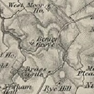
By an application dated 29th January 2007 (amended on 11th February 2007 and 14th November 2007) Mr James Bowen and Mrs Christine Hobson applied to Middlesbrough Council ("the Council") under s. 13 of the Commons Registration Act 1965 ("CRA 1965") to register land known as Site 44, Longridge Wood, Marton West, Middlesbrough as a new town green.
[2]
The original application was accompanied by a Map A which showed the claimed land and the surrounding locality of Marton West. The application was supported by a statutory declaration in prescribed form made by Mrs Hobson dated 29th January 2007 and by a further statutory declaration made by Mrs Hobson on 13th November 2007.
[3]
The application was duly publicised and one objection statement was received. The objector was the Council in its capacity as land owner of Site 44. The objection statement was in the form of a letter dated 11th May 2007.
[4]
No doubt conscious that the Council is both registration authority and objecting landowner, the Council appointed me as an independent barrister to conduct a non statutory public inquiry into the application and to report with my recommendation whether or not Site 44 should be registered as a new green.
[5]
I held the public inquiry in Middlesbrough on 3rd, 4th & 5th. December 2007. I had an accompanied site view and also viewed the site unaccompanied. Mrs Hobson presented the case for the applicants and Mr George Laurence QC and Mrs Jane Evans-Gordon appeared for the objector. I am grateful to the advocates on both sides for their clear and helpful presentation of their respective cases. I must also express my gratitude to Mrs Bernie Carr of the Council who made all the administrative arrangements for the public inquiry with great efficiency.
[6]
After the public inquiry closed, I received an email dated 12th December 2007 from Mr and Mrs Bowen seeking guidance on whether they could submit further evidence. I issued Further Directions on 12th December 2007 dealing with the proposed further evidence but, in the event, none was submitted.
[7]
Also after the public inquiry closed, I received a letter dated 18th December 2007 from Mrs Hobson enclosing some further documents. The letter and its contents were said to be copied to the objector. I have received no comment from the objector. I have looked at the enclosures but they do not seem to me to have any material bearing on my findings of fact or conclusions
2. The History of Site 44
[8]
The local government, planning and development history of Site 44 was explained to the public inquiry by Mr EP Vickers, a planning officer of the Council. His evidence on these matters was not disputed and much was supported by documents produced to the public inquiry. I accept the accuracy of the history as set out below and mostly taken from his evidence.
[9]
Site 44 lies in Marton West, a ward of the Council situated on the southern outskirts of Middlesbrough. Its boundaries are shown on a plan produced to the inquiry. It is a long narrow ward divided into a northern and southern part by a through road called Stainton Way. The western boundary of the ward is formed by the sinuous line of Marton West Beck and the eastern boundary by a main road called Dixon Bank. Marton West ward is a new Council ward, created by The Borough of Middlesbrough (Electoral Changes) Order 2003 . Before the 2003 Order, Marton West formed part of a much larger ward called Newham. The boundaries of the former ward of Newham are also shown on a plan produced to the inquiry.
[10]
The northern part of what is now Marton West ward was developed for housing in the 1940s/1950s. A substantial part of this development consists of a housing estate of fairly uniform character consisting mostly of bungalows and built by a builder called McInnes. It is known locally and to Council officers as the McInnes Estate.
[11]
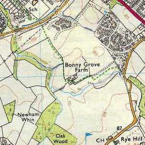
Coulby Newham, the area of Middlesbrough in which Marton West lies, was first identified as an area for major residential development in 1969. A Coulby Newham Master Plan was drawn up in 1976 and subsequently reviewed and revised. A plan of the Third Review was produced to the inquiry. It dates from 1995.The plan shows the scheme for a substantial residential development of the southern part of what is now Marton West ward. The area to be developed is described on the plan as "Neighbourhood E". Neighbourhood E is divided into 19 distinct sites, 10 for private housing and 9 for low cost housing. Site 44 (Longridge) lies at the north-west corner of Neighbourhood E, abutting on Stainton Way to the north and Marton West Beck to the west. It is designated for low cost housing.
[12]
Neighbourhood E has been gradually developed over a number of years. Mr Vickers carried out considerable researches into the dates of the development of various parts of Neighbourhood E, with particular reference to the question how far Neighbourhood E was developed more than 20 years before the date of the town green application, i.e. before 29th January 1987.
[13]
His researches discovered that, in Neighbourhood E, it was only on Site 55 (known as Eagle Park) that development started before 29th January 1987. On no other site was planning permission granted before that date . A study of the registered titles of the properties in Eagle Park showed that only 14 had been sold and transferred to purchasers by January 1987 . A study of the electoral registers showed that only 8 of the Eagle Park properties were occupied by the autumn of 1986 and 32 by the autumn of 1987 .
[14]
The next site to be developed was Site 56 (Bonnygrove). Planning permission was granted on 14th May 1987 and building regulations approvals were granted in 1990-91. None of Site 56 can have been occupied before 1990.
[15]
Building on the rest of Neighbourhood E did not start until 1994/95. Site 44 remains undeveloped.
[16]
In 2005, the Council published a development brief for Site 44. Para. 3.1 describes Site 44 as comprising 3.1 ha of land currently used as informal open space.
Agriculture
[17]
The agricultural history of Site 44 was told to the inquiry by Mr Raymond Wilson. After testing his evidence by cross-examination, Mrs Hobson rightly accepted that he was an honest and truthful witness and I accept his evidence. In her closing statement, Mrs Hobson sought to cast doubt on Mr Wilson's evidence, but I can see no good reason for doing so.
[18]
Mr Wilson's family have been tenant farmers in the Middlesbrough area since the 1930s. In 1951, the statutory predecessor to the Council granted an agricultural Lease of Hall Farm, Nunthorpe to Mr Wilson's father and grandfather. The benefit of the 1951 Lease was assigned to Mr Wilson and his father in 1972.
[19]
In 1987, the Council granted Mr Wilson and his father a licence to farm 93 acres of Bonnygrove Farm and from 1989, the Council granted Mr Wilson and his father an agricultural tenancy of Bonnygrove Farm (by way of addition to the 1951 Lease), subject to determination if required for development purposes. Bonnygrove Farm comprised roughly the western half of Neighbourhood E and included Site 44, which then approximated to a field known as Pylon Field. It was so named after the electricity pylon then situated in the field.
[20]
By a combination of (a) farm diary entries, (b) IACS returns and (c) notes taken by Mr Wilson's wife, Mr Wilson was able to establish the use of the Pylon Field from 1987 onwards:
- 1987-88: oil seed rape
- 1988-89: wheat
- 1989-90: wheat
- 1990-91: winter barley
- 1991-92: oil seed rape.
- 1992-93: wheat
- 1993-94: wheat except for 0.16 ha required for development
[21]
After the 1993-94 season the Pylon Field was surrendered to the Council.
[22]
A typical season's farming of the Pylon Field between 1987 and 1994 involved:
- ploughing in August/September
- drilling or seeding in September
- fertilising in September, March and April
- spraying in March and April (April and June for wheat)
- harvesting between July and September (depending on the crop)
Physical state
[23]
A series of photographs records the history of the physical state of Site 44 over the years:
- a 1981 photograph from the garden of 39, Cheltenham Avenue (north of Stainton Way) shows Site 44 as a field with grass or stubble,
- an aerial photograph of 1981 shows the whole of Neighbourhood E as farmland,
- a 1982 photograph taken from the garden of 39, Cheltenham Avenue shows the Pylon Field as grassland or with a young arable crop,
- a 1983 photograph taken from the garden on 39, Cheltenham Avenue shows the Pylon Field as partly grassland with weeds and partly ploughed
- aerial photographs of 9th May 1992 and 26th June 1992 show the Pylon Field, and indeed the whole of the western part of Neighbourhood E, as farmland,
- photographs of 1994, taken from the garden of 39 Cheltenham Avenue, show the Pylon Field mostly as ploughed farmland but with some excavation works along one edge,
- an aerial photograph of 28th July 1995 shows the Pylon Field as still an open field although there are vehicle tracks along the southern and western boundaries and across the south-western corner
[24]
The photographic evidence is thus wholly consistent with Mr Wilson's evidence of agricultural use until 1994.
[25]
Since the 1993-94 season, Site 44 has not been used for agriculture. Trees have been planted in the centre of Site 44. These trees are still very immature. There are some photographs showing the present state of these trees. Apart from the trees, most of Site 44 is now rough scrubby grassland. See photographs R 1325, 1327 & 1329. Along the eastern edge of Site 44 there are some grassy areas which are kept mown by the Council. See photographs R1325 & 1328. There are also some aerial photographs which were taken in 2000 and 2005 which show an increase in scrub and small trees between 2000 and 2005.
[26]
I had an opportunity to walk around Site 44 on my accompanied and unaccompanied site views. The land generally slopes gently from east to west towards Marton West Beck. Apart from the mown grassy areas to the east and south, the general character of the land is of scrubby grassland with small trees. There are numerous informal paths criss-crossing the land. Site 44 is not suitable for formal games. However, it is eminently suitable and attractive for informal recreation such as dog walking and children's adventure play. There is some wooden fencing around parts of the land, but it is incomplete and fairly decrepit. There are many places to enter the land which do not involve climbing fences. The general impression of the land is of a neglected open space suitable for informal recreation by local people and well used as such.
Rights of way
[27]
Before 2003, a public footpath crossed Bonnygrove Farm in a roughly north to south direction from Stainton Way. It passed along the eastern edge of the Pylon Field.
[28]
By a public path diversion order of 30th January 1995, this footpath was diverted to run westwards along the north side of the Pylon Field (close to Stainton Way) and then southwards parallel with Marton West Beck. It seems clear that the purpose of the diversion order was to facilitate the development of Neighbourhood E.
3. New Greens: Law and Procedure
[29]
At this point, it is convenient to summarise my understanding of the law and procedure relating to the registration of new greens.
[30]
The CRA 1965 provides for each registration authority to maintain a register of town or village greens within its registration area. There was a period expiring on 31st July 1970 for the registration of greens. By s. 1(2)(a) of the 1965 Act, no land which was capable of being registered as a green by the end of the original registration period "shall be deemed to be a town or village green unless it is so registered". Section 13 of the Act provides for the amendment of that register where any land becomes a town or village green after the end of the original registration period.
[31]
The expression "town or village green" is defined by s 22(1) of the Act. It is a three limbed definition, comprising It is the third limb of the definition, i.e. the definition of prescriptive greens, which is relevant in this case. This definition has been altered twice, first, by the Countryside and Rights of Way Act 2000 ("CRoW 2000") and second, by the Commons Act 2006 ("CA 2006").
- statutory greens (i.e. greens created by statute),
- customary greens (i.e. greens based on immemorial use) and
- prescriptive greens (i.e. greens based on 20 years use).
[32]
Until 30th January 2001, the first definition of a prescriptive green was:
"land... on which the inhabitants of any locality have indulged in [lawful] sports and pastimes as of right for not less than twenty years"
[33]
As from 30th January 2001, this definition was replaced, pursuant to s 98 of CRoW 2000, by the following second definition:
"...land on which for not less than twenty years a significant number of the inhabitants of any locality, or of any neighbourhood within a locality, have indulged in lawful sports and pastimes as of right, and either (a) continue to do so, or (b) have ceased to do so for not more than such period as may be prescribed, or determined in accordance with prescribed provisions."
No regulations have been made to implement para. (b) of the second definition and it now seems unlikely that any such regulations will ever be made.
[34]
Section 15 of the CA 2006 was brought into force on 6th April 2007 and contains the following provision for the registration of new prescriptive greens:
- Any person may apply to the commons registration authority to register land as a town or village green in a case where subsection (2), (3) or (4) applies.
- This subsection applies where-
- (a) a significant number of the inhabitants of any locality, or of any neighbourhood within a locality, have indulged as of right in lawful sports and pastimes on the land for a period of at least 20 years; and
- (b) they continue to do so at the time of the application.
- This subsection applies where-
- (a) a significant number of the inhabitants of any locality, or of any neighbourhood within a locality, indulged as of right in lawful sports and pastimes on the land for a period of at least 20 years;
- (b) they ceased to do so before the time of the application but after the commencement of this section; and
- (c) the application is made within the period of two years beginning with the cessation referred to in paragraph (b),
- This subsection applies (subject to subsection (5)) where-
- (a) a significant number of the inhabitants of any locality, or of any neighbourhood within a locality, indulged as of right in lawful sports and pastimes on the land for a period of at least 20 years;
- (b) they ceased to do so before the commencement of this section; and
- (c) the application is made within the period of five years beginning with the cessation referred to in paragraph (b)
However, by para 4 of the Commons Act 2006 (Commencement No 2, Transitional Provisions and Savings) (England) Order 2007, an application made before 6th April 2007 to register a new green continues to be governed by the pre CA 2006 law.
[35]
The main legal issues concerning prescriptive greens that have been decided by the courts are as follows:
What is a Town or Village Green?
[36]
A town or village green is land which is subject to the right of local people to enjoy general recreational activities on it. There is no legal requirement that it should consist mainly of grass, be situated in or in reasonable proximity to a town or village, or be suitable for use by local inhabitants for traditional recreational activities. Greens which were not registered by 31st July 1970 ceased in law to be town or village greens and, so long as they remain unregistered, local people have no recreational rights over them.
What is the Effect of Registration?
[37]
The effect of registration can be summarised as follows.
- The fact that land is registered as a green is conclusive evidence that it was a green as at the date of registration.
- Land becomes a new green only when it is registered as such.
- Registration as a new green confers general recreational rights over the green on local people
- Registration as a new green subjects the land to the protective provisions of s. 12 of the Inclosure Act 1857 and s. 29 of the Commons Act 1876, which in practice preclude development of greens
Which definition applies?
[38]
In the case of any application to register a new green made after 30th January 2001, and before s. 15 of the CA 2006 came into force, only the second definition applies . This, therefore, is the relevant definition in the present case.
What is the meaning of the second definition?
Oxfordshire County Council v Oxford City Council & anor [2006] 2 AC 674 per Lord Hoffmann at paras 3-16, & 37-39, Lord Rodger at para 115 & Lord Walker at paras 124-128 (Lord Scott dissenting at paras 71-83)
Oxfordshire per Lord Hoffmann at para. 18.
Commons Registration Act 1965 s. 10
Oxfordshire per Lord Hoffmann at para 43, Lord Scott at para 110, & Lord Rodger at para 116 (Lady Hale dissenting at para 142 in relation to original definition)
Oxfordshire
Oxfordshire
Oxfordshire per Lord Hoffmann at para 43, Lord Scott at para 110, Lord Rodger at paras 117-123 & Lord Walker at para 124. Lady Hale dissented at para 147.
[39]
The meaning of the second definition has also been extensively considered by the courts.
Land...
...on which for not less than 20 years...
[40]
The 20 year period must be the 20 years immediately before the s. 13 application
...a significant number...
[41]
"Significant" does not mean considerable or substantial. What matters is that the number of people using the land in question has to be sufficient to indicate that their use of the land signifies that it is in general use by the local community for informal recreation, rather than occasional use by individuals as trespassers.
...of the inhabitants of any locality...
[42]
A "locality" cannot be created by drawing a line on a map . A "locality" must be some division of the county known to the law, such as a borough, parish or manor. An ecclesiastical parish can be a "locality". It will be seen that the courts have adopted a very narrow construction of "locality" which catches out many lay applicants
for registration of new greens. The House of Lords in the Oxfordshire case recognised and upheld the narrowness of this definition of "locality". Lord Hoffmann said that it had been decided in the Sunningwell case that the narrowness of the definition was qualified only by the fact that it was sufficient if the recreational users of the green came "predominantly" from the relevant locality . However, I think that it must be borne in mind that that this qualification was applied on consideration of the first, and narrower, definition of a prescriptive green in the Sunningwell case. Under the second definition, the test is not whether the users come predominantly from the relevant locality or neighbourhood, but whether a significant number of the users come from such locality or neighbourhood.
...or of any neighbourhood within a locality...
[43]
A "neighbourhood" need not be a recognised administrative unit. A housing estate can be a neighbourhood . However a neighbourhood cannot be any area drawn it must have some degree of cohesiveness . A neighbourhood need not lie wholly within a single locality . In the Oxfordshire case, Lord Hoffmann pointed out the "deliberate imprecision" of the expression. I am inclined to the view that the statutory test is fulfilled if the applicants can prove that a significant number of qualifying users come from any area which can reasonably be called a "neighbourhood" even if significant numbers also come from other neighbourhoods.
Oxfordshire case per Lord Hoffmann at para s 41-42 & 60, Lord Rodger at para 114 & Lord Walker at para 124. Lady Hale dissented at para 147.
R (McAlpine) v Staffordshire CC [2002] EWHC 76 (Admin) at para. 77
R (Cheltenham Builders Ltd) v South Glos, DC [2004] 1 EGLR 85 at paras 41-48
Ministry of Defence v Wiltshire CC [1995] 4 All ER 931 at p 937b-e, R (Cheltenham Builders Ltd) v South Glos. DC at paras 72-84 and see R (Laing Homes Ltd) v Buckinghamshire CC [2003] 3 EGLR 69 at para. 133
R (Laing Homes) Ltd v Buckinghamshire CC
Oxfordshire per Lord Hoffmann at para. 25 applying the ruling of the House of Lords in R v Oxfordshire County Council ex. p. Sunningwell Parish Council[2000] 1 AC 335.
R (McAlpine) v Staffordshire CC
...have indulged in lawful sports and pastimes...
[44]
The words "lawful sports and pastimes" form a composite expression which includes informal recreation such as walking, with or without dogs, and children's play . It does not include walking of such a character as would give rise to a presumption of dedication as a public right of way .
...as of right...
[45]
In my view, the cases disclose three threads in the requirement that recreational use of the application land must be "as of right":
- use of land "as of right": must be use which is without force, stealth or permission ("nec vi nec clam nec precario":) and does not turn on the subjective beliefs of users.
- Use of land "as of right" must be use as a trespasser and not use "by right", i.e. pursuant to a legal right.
- Use of land "as of right" must have the appearance of the exercise of a legal right.
[46]
As to the first thread:
- "Force" does not just mean physical force. User is by force in law if it involves climbing or breaking down fences or gates, if it involves ignoring notices prohibiting entry, or if it is under protest.
- Use that is secret or by stealth will not be use "as of right" because it would not come to the attention of the landowner
- "Permission" can be express, e.g. by erecting notices which in terms grant temporary permission to local people to use the land. Permission can be implied, but permission cannot be implied from inaction or acts of encouragement by the landowner. The effect of permissive signs to preclude continuing user as of right will, in the case of post 6th April 2007 applications, be affected by CA 2006 s. 15(7)(b).
- In the Sunningwell case, the House of Lords said that use "as of right" meant use which is without force, stealth or permission. However, I think that it would be wrong to treat Sunningwell as if it had amended the statute to substitute "without force, stealth or permission" for the words "as of right". In Sunningwell, the House was considering the issue whether users had to have a subjective belief that they were exercising the right claimed. In rejecting the requirement for such subjective belief, the House emphasised the objective nature of user "as of right".
[47]
As to the second thread, if user is pursuant to a legal right, e.g. under a statutory trust for public recreation, it is "by right" rather than "as of right".
This point was fully discussed by the House of Lords in the Beresford case, and it illustrates the fact that "as of right" does not just mean "without force, stealth or permission".
User as of right must also be trespassory.
[48]
As to the third thread, there are hints in the speeches of Lord Hoffmann in the Sunningwell and Oxfordshire cases
(a) that qualifying recreational user must have the appearance to the landowner of the exercise of a legal right and
(b) that this appearance may be affected by the interaction between the use of the land made by the landowner and by local people.
Lord Hoffmann rejected the view expressed in the Laing Homes and Humphries cases that land could not acquire town or village green status
if the landowner was using the land for purposes that would be unlawful under IA 1857 s. 12 or CA 1876 s. 29 if the land were a green.
In cases where the land is subject to low level use by the landowner, there may be no conflict between the use of the land by the landowner and the recreational use of the land by local people.
There must be give and take between the landowner and local recreational users. However, if recreational use by local people materially defers to the use by the landowner,
the recreational use may not have the appearance to the landowner of use "as of right".
[49]
I therefore conclude that user "as of right" means user which is:
- not forcible, secret or permissive ("nec vi nec clam nec precario").
- trespassory and not pursuant to a legal right, i.e. "as of right" as opposed to "by right",
- has the appearance to the landowner of the exercise of a legal right
...and continue to do so.
[50]
It was decided by the House of Lords in the Oxfordshire case is that the relevant user must continue down to the date of the application: user need not continue down to the date of registration .
R (Cheltenham Builders Ltd) v Sth Glos. CC at para 85 Oxfordshire case per Lord Hoffmann at para 27 disapproving R (Cheltenham Builders Ltd) v Sth. Glos. CC at para. 88 R v Oxfordshire CC ex p. Sunningwell PC at pp 356F-357E Oxfordshire CC v Oxford CC [2004] Ch 253 at paras 96-105 R v Oxfordshire CC ex p Sunningwell PC R (Beresford) v Sunderland CC paras 3, 9 & 30 Newnham v Willison (1987) 56 P&CR 8 R (Beresford) v Sunderland City Council [2004] 1 AC 889
Human Rights
[51]
The majority view of the House of Lords in the Oxfordshire case was that the creation of a new green by prescription did not infringe the landowner's human rights under
art. 1 of the 1st Protocol to the ECHR.
[2004] P&CR 573
Humphreys v Rochdale MBC (2004) unreported
Oxfordshire case: Lord Hoffmann at para 44, Lord Rodger at para 114, Lord Walker at para 124 & Lay Hale at para 143. Lord Scott, at para 109, would have allowed recreational use to cease shortly before the date of the application provided that the application was made reasonably promptly after interruption
Procedure
[52]
Procedure on applications to register new greens under the CRA 1965 is governed by The Commons Registration (New Land) Regulations 1969.
These regulations have proved quite inadequate to resolve many disputed applications and registration authorities have had to resort to procedures not contemplated by the
Regulations to deal with such applications.
Who can apply?
[53]
Anyone can apply to register land as a new green, whether or not he is a local person or has used the land for recreation.
Application.
[54]
Application is made by submitting to the registration authority a completed application form in Form 30. The form asks a series of questions which are very hard in practice to answer. The House of Lords in the Oxfordshire case has emphasised that the procedure is intended to be simple and informal and that applications are not to be defeated by technical objections to the form of applications provided that the applications are handled in a way which is fair to all parties . The form has been replaced in relation to post 6th April 2007 applications.
- ★ Part 3 asks for the "locality" of the application land. Few people completing the form are aware of the narrow technical meaning given by the courts to "locality".
- ★ Part 4 asks the applicant to state on what date the land became a green. This question is now hard to answer in the light of the House of Lords ruling that land does not become a new green until it is registered. Probably the correct answer is the date of the application.
- ★ Part 5 asks how the land became a green. This question is now also hard to answer in the light of the House of Lords ruling that land does not became a new green until it is registered. Probably it means: how did the land become land which qualifies for registration as a new green?
Accompanying documents.
[55]
Although the application form has to be verified by a statutory declaration by the applicant or his solicitor, there is no requirement that the application should be accompanied by any other evidence to substantiate the application. Instead, reg. 4 provides for the application to be accompanied by any relevant documents relating to the matter which the applicant may have in his possession or control or of which he has the right to production. In most cases, there are few, if any, of such documents as the application turns simply on a claim that the application land has been used for recreation by local people for more than 20 years.
Lord Hoffmann at paras 60-62, Lord Scott at para 110, Lord Walker at para 124 & Lady Hale at para 144.
Evidence.
[56]
The applicant is only required to produce evidence to support the application if the registration authority reasonably requires him to produce it under reg. 3(7)(d)(ii).
Preliminary consideration.
[57]
After the application is submitted, the registration authority gives it preliminary consideration under reg. 5(7). The registration authority can reject the application as not "duly made" at this stage, but not without giving the applicant an opportunity to put his application in order. This seems to be directed to cases:
- where Form 30 has not been duly completed in some material respect,
- where the application is bound to fail on its face, e.g. because it alleges less than 20 years use or
- where the supporting documents disprove the validity of the application
Publicity.
[58]
If the application is not rejected on preliminary consideration, the registration authority proceeds under reg. 5(4) to publicise the application:
- By notifying the landowner and other people interested in the application land
- By publishing notices in the local area, and
- By erecting notices on the land if it is open, unenclosed and unoccupied.
Objectors.
[59]
Anyone can object to an application to register a new green, whether or not he or she has any interest in the application land.
Objection Statement.
[60]
Any objector has to lodge a signed statement in objection. This should contain a statement of the facts relied upon in support of the objection. There is a time limit on service of objection statements. The time limit is stated in the publicity notices issued by the registration authority. However, the registration authority has a discretion to admit late objection statements.
Determination of application.
[61]
The most striking feature of the regulations is that they provide no procedure for an oral hearing to resolve disputed evidence. The Commons Commissioners have no jurisdiction to deal with disputed applications to register new greens: R (Whitmey) v Commons Commissioners The regulations seem to assume that the registration authority can determine disputed applications to register new greens on paper. A practice has grown up, repeatedly approved by the courts, most recently by the House of Lords in the Oxfordshire case, whereby the registration authority appoints an independent inspector to conduct a non statutory public inquiry into the application and to report whether it should be accepted or not. In some cases, procedural fairness will make an oral hearing not merely an option but a necessity . In the Whitmey case, it was held that the procedure by non statutory public inquiry did not infringe art. 6 of the ECHR because any decision of the registration authority is subject to review by the courts.
Procedural issues.
[62]
A number of important procedural issues have been decided by the courts:
- Burden and Standard of Proof. The onus of proof lies on the applicant for registration of a new green, it is no trivial matter for a landowner to have land registered as a green, and all the elements required to establish a new green must be "properly and strictly proved" . However, in my view, this does not mean that the standard of proof is other than the usual flexible civil standard of proof on the balance of probabilities.
- Defects in Form 30. The House of Lords has held in the Oxfordshire case that an application is not to be defeated by drafting defects in the application form, e.g. where the wrong date has been inserted in Part 4. The issue for the registration authority is whether or not the application land has become a new green
- Part registration. The House of Lords also held in the Oxfordshire case that the registration authority can register part only of the application land if it is satisfied that part but not all of the application land has become a new green. Indeed, the House thought that a larger or different area could be registered if there was no procedural unfairness.
4. The Case for Applicants
Neighbourhood/Locality Issue
[63]
As is apparent from the above discussion, the requirement that recreational use must be by a significant number of the inhabitants of any locality or of any neighbourhood within a locality raises a number of difficult legal issues. In my experience, applicants without legal representation struggle with the formulation of their case in relation to this requirement. The applicants in this case were no exception.
[64]
Their original case was that recreational use was by a significant number of the inhabitants of the locality of Marton West as shown on Map A. This showed as the locality the bulk of the post 2003 ward of Marton West. However, the base map used for Map A did not show the whole of the ward and so the boundaries of the locality were arbitrarily cut off at the end of the map and exclude parts of Marton West ward.
[65]
The applicants reconsidered this requirement on several occasions before and during the public inquiry:
[66]
I made it clear during the public inquiry that I did not consider myself bound by the way in which the applicants formulated their case on the locality/neighbourhood point, but that I would feel free to draw my own conclusions on the point from the evidence presented to the public inquiry. I should record that counsel for the objectors submitted that I was bound by the applicants formulation.
Evidence for Applicants
[67]
I now turn to consider the evidence adduced by the applicants on the issue whether there has been 20 years qualifying recreational use of the application land. The applicants called a considerable number of witnesses to give oral evidence. The applicants also relied on a very large number of statements and evidence questionnaires completed by local residents. I will deal first with the oral evidence and then I will deal with the written evidence. For convenience, I will deal with the witnesses who gave oral evidence in alphabetical order rather than in the order in which they gave evidence.
Mrs Jeanette Bowen
[68]
Mrs Bowen has lived in Cheltenham Avenue (on a part of that road which is not on the McInnes Estate) since 1982. Her garden backs onto Stainton Way and the application land is on the other side of Stainton Way.
[69]
Mrs Bowen produced an evidence questionnaire dated 27th January 2007. It is in a form devised by the Open Spaces Society. This form was used by all witnesses who completed evidence questionnaires. The questionnaire verified Map A as showing the relevant locality. She said that she had used the application land almost daily for informal recreation such as walking and bird-watching and that she saw others doing the same. In answer to Q10 ("during the time you have used the land has the general pattern of use remained basically the same?") she replied: "From farmland to fallow/open space. Then trees planted by a Charity. Public footpath always available".
[70]
Mrs Bowen also produced a written statement dated 12th November 2007 and signed jointly with her husband. This statement said that in 1982 they had a good view across Stainton Way to "the cultivated farmland on the other side of Stainton Way" They had access to the land by way of a public footpath leading from a stile on the other side of Stanton Way. Access to the application land was totally opened up when the housing developments started. Site 44 developed into a much used site, a natural play area.
[71]
In her oral evidence, Mrs Bowen maintained that the application land lay fallow and available for general recreation at all times from 1982 with the sole exception that it was ploughed in 1993/4. It seems to me that this evidence is plainly incorrect:
- It is inconsistent with the evidence of Mr Wilson (whose evidence I accept and who was accepted by Mrs Hobson to be an honest witness) of continuous arable use from 1987 to 1994
- It is inconsistent with the aerial photographs analysed in section 2 above
- It is inconsistent with the photographs produced by Mrs Bowen herself: see in particular the photographs of 1982 and 1983 taken from Mrs Bowen's garden
- It is inconsistent with her evidence questionnaire where she described the application land as changing from farmland to fallow
- It is inconsistent with her written statement that she had a view across Stainton Way to the cultivated farmland on the other side.
[72]
In the circumstances, I do not regard Mrs Bowen's evidence to be reliable in relation to the condition and use of the application land before agricultural use ceased in 1994.
Mrs. Kathleen Dorothy Chillemi
[73]
Mrs Chillemi has lived in Cheltenham Avenue (on the McInnes Estate) since 1978.
[74]
Mrs Chillemi produced an evidence questionnaire dated 25th January 2007. She verified Map A as showing the relevant locality. She said that, although she had known the land since 1978, she had only used it since 1985. She used the land weekly for walking and bird watching. She saw other people using the land for informal recreation. She made no mention of agricultural use of the land save to say that it had been known as Bonny Grove Farm. In answer to Q10 she said that the general pattern of use had remained basically the same since 1985.
[75]
Mrs Chillemi also produced a written statement (made jointly with her husband) dated 30th October 2007. The statement dealt with current use of the application land but did not deal with historical use during the relevant 20 year period.
[76]
The gist of Mrs Chillemi's oral evidence was that:
- She had used the application land for recreation since 1978
- The statement in her evidence questionnaire that she had only used it since 1985 was a mistake: she used the land more after 1985 because she retired from work
- She used to walk her dog across the fields of Bonnygrove Farm
- She could not be sure which of the fields is now Site 44
- She could not remember any crops on Site 44
- She would not walk or let her dog run on growing crops
[77]
Mrs Chillemi's evidence is inconsistent with the evidence of Mr Wilson (which I accept and which is supported by photographic evidence) that Site 44 was in use for growing arable crops annually until 1994. Nor can I understand how she can say that the general pattern of use of the application land has remained unchanged so long as she has used the land. I consider that her evidence concerning the condition and use of the application land before agricultural use ceased in 1994 is unreliable. I think that the probability is that Mrs Chillemi occasionally walked her dogs over the footpaths of Bonnygrove Farm before 1994, has no real recollection of the condition of Site 44 before 1994, and has used Site 44 generally for recreation only since it became de facto open amenity land after agricultural use ceased in1994.
Mrs Sheila Cookson
[78]
Mrs Cookson has lived in Grange Crescent, on the McInnes Estate, since 1982.
[79]
Mrs Cookson submitted an evidence questionnaire dated 24th January 2007. The evidence questionnaire verified Map A as showing the relevant locality. Apart from saying that the application land was formerly known as Bonny Grove Farm and that the land was used by more people at present, the questionnaire did not address the issue of the agricultural use of the land until 1994. The evidence questionnaire proceeded on the basis that Mrs Cookson had used the application land for recreation probably weekly since 1982.
[80]
Mrs Cookson also submitted a written statement. She said that when her children were small she regularly took them across Stainton Way to play on Site 44 and continued to enjoy the land as a family. It emerged in her oral evidence that her children were born in 1973 and 1976, so that her evidence of children's play must relate principally to the 1980s and perhaps early 1990s.
[81]
In her oral evidence, Mrs Cookson said that in 1986/87 she acquired a dog and walked it a lot on the application land. However, she also said that the application land was always open access scrubby land. She can not remember that it was ever cultivated and she would never walk over farmer's fields. I find this evidence impossible to reconcile with the clear evidence that Site 44 was cultivated farmland until 1994 and became open scrubby land only after agricultural use was abandoned in 1994. I can only conclude that Mrs Cookson's recollection of the condition and use of the application land before agricultural use ceased in 1994 is unreliable.
Mrs Janet Francis
[82]
Mrs Francis has lived in Claremont Drive (on the McInnes Estate) since 1983. From 1979-83, she lived in The Croft, also on the McInnes Estate.
[83]
Mrs Francis produced an evidence questionnaire dated 22nd August 2007. In the evidence questionnaire, she verified Map C as showing the relevant locality. She said that she used the land (apart from the public paths) twice a week for walking from 1979-1988 and then from 2002 onwards. The land was open unoccupied land used by people for informal recreation. In answer to Q10, she said that since 1979 the general pattern of use of the land had remained basically the same: "always been able to walk over the land".
[84]
Mrs Francis also produced a written statement dated 28th October 2007. She said that she, her husband and children had freely accessed the application land for the last 28 years. They have always regarded the land as being freely available to all.
[85]
In oral evidence in chief, Mrs Francis said that, although she remembered crops on the application land, there was nothing there in the winter months. She remembers sledging on the land with her children. When they had dogs, they walked them on the application land.
[86]
Under cross examination from Mr Laurence QC, it appeared to me that the accuracy of Mrs Francis's evidence about the application land was put in doubt:
- When asked why she said in her evidence questionnaire that she did not use the application land between 1988 and 2002 whereas she said in her written statement that she had used it for the last 28 years, she said that she should have said in her evidence questionnaire that she used it less between 1988-2002. Then she said that when she said 1988 she should have said 1990. She did not use the land much after 1990 but her children did. Then she said that she walked the application land about once a month after 1990.
- When asked about agricultural use of the land, she said that she could not remember farming on the land although her children remembered oil-seed rape growing there. If there had been oil-seed rape she would have tended to walk around the perimeter of the field. But that was not to say that she had not walked across the field Mrs Lee has lived in Rushmere (Site 45 in Neighbourhood E) since October 1995 when she moved into her newly built house. Mrs Lee has lived in Rushmere (Site 45 in Neighbourhood E) since October 1995 when she moved into her newly built house. "I am sure that I have at some time."
[87]
In re-examination by Mrs Hobson, she said that she could not really remember whether there were any footpaths across the land.
[88]
In answer to questions from me she said that she could not remember any specific incidents which led her to answer Q8 in her evidence questionnaire to the effect that she did not use the land between 1988 and 2002. She could not remember when the trees were planted on the application land.
[89]
Giving all due allowance for the stress of giving evidence to a public inquiry, I am bound to say that I found Mrs Francis to be a very unsatisfactory witness. I am driven to the conclusion that she has no reliable recollection concerning recreational use of the application land before agricultural use ceased in 1994.
Mr John Harrison
[90]
Mr Harrison has lived in Neasham Avenue (on the McInnes Estate) since 1976.
[91]
Mr Harrison produced an evidence questionnaire dated 11th February 2007. In the questionnaire, Mr Harrison verified Map B as showing the relevant locality and said that he had used the application land several times a year since 1976 for outdoor relaxation such as walking and watching wildlife. The land was formerly known as Bonnygrove Farm but the general pattern of use has remained basically the same since 1976. He has seen other people on the application land enjoying informal recreation.
[92]
Mr Harrison produced a written statement dated 31st October 2007. In this statement, Mr Harrison said that he had often visited and walked across the site since 1976 and has seen other people using the site throughout.
[93]
In his oral evidence, Mr Harrison said that he would normally keep to a footpath over a cultivated field but that he did not remember this particular field being cultivated. He was not a regular walker but he had walked over this land many times since 1976.
[94]
It appears to me that, if Mr Harrison had walked over the Pylon Field between 1987 and 1994 he could not have failed to notice that it was a cultivated arable field. I can only conclude that Mr Harrison has no reliable recollection of use of the application land over those years.
Mr. William Hayes
[95]
Mr William Hayes has lived in Knaresborough Avenue (on the McInnes Estate) since between 1983 and 1986.
[96]
Mr Hayes submitted an evidence questionnaire dated 21st August 2007. The evidence questionnaire verified Map C as showing the relevant locality. Mr Hayes said that he has used the application land (apart from the public footpath) weekly for walking and watching wildlife since 1983. Apart from saying that the land was formerly known as Bonnygrove Farm, he does not mention agricultural use of the land. In answer to Q10 he said that the general pattern of use of the application land had remained basically the same since 1983.
[97]
Mr Hayes also submitted a short written statement dated 29th October 2007 jointly with his wife. It says that they have walked over the land known as Site 44 many times over the last 20 years to observe wildlife. Again, there is no mention of agricultural use of the land until 1994.
[98]
When cross examined by Mr Laurence QC about agricultural use of the land, I found his evidence rather confusing. I think that his ultimate evidence was that:
- he crossed Site 44 as part of a much longer walk,
- he could only recall Site 44 being cultivated during one year (c. 1990)
- the crop was oil-seed rape,
- it was planted over the public footpath and
- he walked through the oil-seed rape where it was growing on the public footpath.
[99]
I find Mr Hayes's evidence impossible to reconcile with the clear evidence that the application land was in annual arable cultivation until 1994. I think that Mr Hayes's evidence of use until 1994 is unreliable and I am not satisfied that he did more than use the public footpath which crossed the land until agricultural use of the application land ceased in 1994.
Mr. John Hobson
[100]
Mr Hobson is the husband of Mrs Hobson, one of the applicants. Mr and Mrs Hobson have lived in Buxton Avenue (on the McInnes Estate) since 1997.
[101]
Mr Hobson produced an evidence questionnaire dated 28th January 2007. The questionnaire verified Map A as showing the relevant locality. Mr Hobson stated that he had known and used the application land 2 or 3 times a week for informal recreation since 1997 and had seen others doing the same.
[102]
Mr Hobson also produced a written statement (signed jointly with Mrs Hobson) giving similar evidence concerning recreational use of the application land since 1997.
[103]
Mr Hobson also gave oral evidence to like effect. He also gave evidence and produced a plan to illustrate how people could walk across a cultivated field without harming the crops. However, this was just speculation so far as actual use of the application land while under cultivation was concerned.
[104]
I accept Mr Hobson's evidence concerning his own use of the application land and of the use by others that he had seen. Of course, he only knew the land after agricultural use ceased and the land had become an informal recreational open space.
Mr. David Laing
[105]
Mr Laing has lived in Worsley Crescent, on the McInnes Estate, for 24 years.
[106]
On 22nd October 2007, he completed an evidence questionnaire . The questionnaire verified Map C as showing the boundaries of the claimed land and of the locality. Mr Laing said that he had used the application land (apart from the public paths) since 1984. He recognised that, during that time, it had changed from arable farmland, part of Bonnygrove Farm, to an amenity space known as Site 44. The constant was the public footpath. He had used the land once or twice a week for walking, jogging and bird-watching. He had seen various informal recreational activities on the land. He never sought permission to use the land and his use was never prevented or discouraged.
[107]
On 1st November 2007, Mr Laing signed a written statement . This statement makes it clear that his access over the application land was on the public right of way.
[108]
In oral evidence, Mr Laing said that, before diversion of the definitive footpath in 2003, he used not only the definitive footpath but also the route alongside Marton West Beck onto which it was diverted.
As to general use of the land for recreation, Mr Laing said that he would feel free to use the land if not under cultivation but would respect the farmer if the land was under cultivation.
He thought that the application land sometimes lay fallow. When specifically asked if he walked on the application land other than on the public footpath when the land was still in agricultural use,
he replied that "I may have walked on [the application land] when it was under cultivation but had no crops on it".
[109]
I conclude that Mr Laing did not use Site 44 generally for recreation until after agricultural use stopped in 1994. Until then he used the definitive public footpath and the informal path alongside Marton West Beck onto which the definitive path was diverted in 2003. He gave no evidence that anyone else used the application land generally for recreation before 1994.
Mrs Angela Lee
[110]
Mrs Lee has lived in Rushmere (Site 45 in Neighbourhood E) since October 1995 when she moved into her newly built house.
[111]
She produced an evidence questionnaire dated 25th January 2007. It verified Map A as showing the relevant locality. Mrs Lee also produced a written statement dated 9th October 2007. The effect of Mrs. Lee's written and oral evidence was that she has only known Site 44 since the end of 1995 and that it has always been open land used by local people, including herself and family for informal recreation. There was some fencing around the land but it was not complete, so that access was never impeded.
[112]
Save as to the question of locality (where the locality verified by her evidence questionnaire is no longer pursued by the applicants) I accept Mrs Lee's evidence.
Norman Leslie
[113]
Mr Leslie has lived in Cambridge Avenue (on the McInnes Estate) since 1986. Before that he had lived in Gypsy Lane (to the east of Dixon Bank) since 1974.
[114]
Mr Leslie submitted an evidence questionnaire dated 21st March 2007. It verified Map C as showing the relevant locality. In the questionnaire, Mr Leslie stated that he had known the application land since 1974 and had occasionally used it for dog walking since 1986. The general pattern of use had remained the same since 1986. Other people used the land for various types of recreation. The land was unoccupied. There was no reference to agricultural use of the land save that it was formerly known as Bonnygrove Farm.
[115]
Mr Leslie also submitted a written statement made jointly with his wife in November 2007. It stated that they had used the application land for general exercise and dog walking "on intermittent occasions". They met and frequently observed other people enjoying recreation on the land, which was traversed by many ancient footpaths. Again, there was no mention of agricultural use of the land.
[116]
In his oral evidence, Mr Leslie said that he had never seen the application land under cultivation. Under normal circumstances he would not walk across a cultivated field. He occasionally walked the informal paths across the land. There was a fence along the northern edge of the Pylon Field which had a stile in it which he used to access the field. He indicated the position of the stile on an aerial photograph .
[117]
I cannot accept Mr Leslie's evidence that the application land was uncultivated between 1986 and 1994. In these circumstances, I am not satisfied that his recreational use of the application land extended beyong used of the footpath until agricultural use ceased in 1994.
William Mellor
[118]
Mr Mellor has lived in Worsley Crescent (on the McInnes Estate) since 1992.
[119]
Mr Mellor produced an evidence questionnaire dated 29th September 2007. He said that he had used Site 44 (formerly known as Bonny Grove Farm) since 1992 for dog walking and observing wildlife. He had seen a number of informal recreational activities on the land. He left a number of questions unanswered, including Q15 which asked how often he used the land (apart from the public paths). In answer to Q10, he said that the general pattern of use of the application land ad remained basically the same since 1992.
[120]
Mr Mellor also produced a written statement signed by himself and his wife. This statement says that they have walked through "Site 44 and its surroundings at least once a week, walking our son's dog along the many public footpaths and tracks in the whole area". This seems to suggest walking along paths rather than general recreation over the whole of Site 44.
[121]
In his oral evidence, he said that, when he moved to Worsley Crescent in 1992, Site 44 was already scrubland. Until the local school was extended recently, he could see the whole of Site 44 from the window of his house. He has never seen any crops on Site 44. He and his wife had never walked through crops. He walked weekly across Site 44 as part of a longer walk. He normally walked along the public footpath or along the track parallel with Martin West Beck, but sometimes he cut across Site 44.
[122]
Mr Mellor's evidence that the application land was already scrubland in 1992 is disproved by the aerial photographs of May and June 1992 and by the applicants' photographs of 1994 . I consider that Mr Mellor's evidence about the condition and use of the application land before agricultural use ceased in 1994 is unreliable.
Rajesh Nanda
[123]
Dr. Nanda has lived with his family in Shandon Park (Site 46A of Neighbourhood E) since 2002.
[124]
Dr. Nanda produced an evidence questionnaire dated 24th January 2007. He verified Map A as showing the relevant locality. He stated that he had known the application land since 2002 and that, since then, it had been used by himself, his family and many others for informal recreation.
[125]
Dr. Nanda produced an undated written statement describing use of the application land for informal recreation since 2002. He produced some photographs of his family in the snow on part of the application land.
[126]
In his oral evidence he said that the application and was already planted with trees in 2002. Dr Nanda's evidence was not challenged by the objector and I accept it.
Mrs Amanda Pearson
[127]
Mrs Pearson produced an undated written statement . She and her husband moved into Eagle Park in 1990 and then moved to Rushmere (i.e. Site 45 in Neighbourhood E) in 1996/7. Whilst living in Eagle Park, she and her husband used frequently to walk over the application land. Since moving to Rushmere, she and her family have used the application land more frequently for informal recreation.
[128]
In her oral evidence, Mrs Pearson was less certain about the extent of her use of the application land before moving to Rushmere: "I am sure that we would have walked Site 44 at some point". In cross examination, Mrs Pearson seemed rather vague about the routes walked before moving to Rushmere. One route she described was along the western and northern sides of the application land (which seemed to imply that she did not use the application land generally for recreation). She seemed to have no clear recollection of arable cultivation of the application land, although she said that she would not have used the land for recreation while it had a crop on it.
[129]
I have no hesitation in accepting Mrs Pearson's evidence about recreational use of Site 44 after she and her family moved to Rushmere in 1996/97. By that date agricultural use of the land had ceased and it was open land used by local people for recreation. However, I am not satisfied that she made general recreational use of the application land in the years before 1995 when it was under regular arable cultivation. I consider that, at most, she and her husband may have walked around the sides of the field in those years.
Mrs Sharon Pemberton
[130]
Mrs Pemberton and her husband have lived in Rushmere (i.e. Site 45 in Neighbourhood E) since December 1994.
[131]
She produced an evidence questionnaire dated 24th January 2007. It verified Map A as showing the relevant locality. She also produced an undated written statement . The effect of her written and oral evidence was that Site 44 was stubble when she moved into her house. It was not farmed during her time and was used by herself, her family and other local people for informal recreation such as walking and children's play. There was a site office for the Rushmere development to the east of Site 44 although she could not say exactly where it was.
[132]
Save as to the question of locality (where the locality verified by her evidence questionnaire is no longer pursued by the applicants) I accept Mrs Pemberton's evidence.
Mr. James Smiles
[133]
Mr Smiles lives in Raylton Avenue, on the McInnes Estate.
[134]
On 24th August 2007 he signed an evidence questionnaire . He verified Map C as showing the claimed land and the relevant locality. He said that he had known and used for informal recreation the land now known as Site 44, and formerly known as Bonnygrove Farm, since 1953. He had used it once or twice a week. He had seen others doing the same. In answer to Q10, he said that the local council planted trees on the land "over 20 years ago". I think that his recollection on this point must be wrong since the trees could not have been planted until after arable use ceased in 1994.
[135]
Mr Smiles produced a written statement dated 21st October 2007. He has lived in Middlesbrough all his life and is now aged 77. In 1946 he lived in the centre of Middlesbrough. He was a keen cross country runner. He heard of "Longridge Wood" and used to train by running to Longridge which had open access. There were lots of people walking and exercising their dogs. In 1954 he married and moved to Acklam. He continued to use the land for training. In 1985 he moved to Marton an he and his wife walked Longridge daily. Since then "various developments have taken place" and Longridge has developed into a natural habitat for wildlife. It is used for recreation by local people. Mr Smiles did not mention any agricultural use of the application land.
[136]
In his oral evidence, Mr Smiles accepted that the application land was sometimes cultivated. He said that, although he generally used the public footpath, he also ran across the fields, jumping over the furrows. This evidence must, I think, relate to his training in the years of his youth long before he moved to the McInnes Estate.
[137]
It seemed to me that neither in his written nor his oral evidence did Mr Smiles face up to and address the fact that the application land was in use for arable farming as part of Bonnygrove Farm at least from 1987 to 1994, i.e. during the first seven years of the relevant 20 year period. While I do not doubt that Mr Smiles and his wife regularly walked the public footpaths across Bonnygrove Farm, I am not satisfied that Mr Smiles and his wife either used the application land generally for recreation during this period or saw others so using it.
Mr. Stuart Walker
[138]
Mr Walker has lived in Eagle Park since 1986. Mr Vickers's researches have discovered that the transfer to Mr Walker was dated 6th December 1986 .
[139]
Mr Walker completed an evidence questionnaire dated 30th August 2007. He verified Map C as showing the application land and the relevant locality. He said that he had known and used the application land from 1986 onwards. The land was formerly known as Bonnygrove Farm. In answer to Q10 (about the general pattern of use)
he said that "the land was originally fields with a right of way". He said that he and his family used the land for various sorts of informal recreation and saw others doing the same. He said that his use of the land varied from daily to two or three times a week. However, it is not clear from the evidence questionnaire whether this was on or off the public footpath or
whether the pattern of use changed when agricultural use ceased.
[140]
Mr Walker submitted a written statement dated 12th November 2007. It speaks of use of the application land by himself his family and others, but, again, it is not clear from the statement whether this was on or off the public footpath or whether the pattern of use changed when agricultural use ceased.
[141]
In oral evidence, Mr Walker said that when he moved to Eagle Park, Site 44 was just one of the fields in the open farmland west of Eagle Park forming part of Bonnygrove Farm. He walked over all those fields. He could not remember whether there were ever any crops on the field now forming Site 44, but (a) he could walk along the furrows without damaging the crop and (b) the land would not be under crop all the year round.
[142]
I am not satisfied that Mr Walker made or saw any material recreational use of the application land before agricultural use stopped in 1994 except for use of the public footpath. If, as claimed in his evidence questionnaire, he was using it at least once a week, I think that he would have remembered that it was in use for arable farming until 1994. His evidence about walking the furrows seemed to me to be pure conjecture.
Written Evidence
[143]
In addition to the witnesses called to give oral evidence, the applicants submitted a large number of written statements from witnesses who did not attend the public inquiry to give oral evidence.
These witnesses comprised Mr Tyerman , Mr Potter , Mr Doublet (who all originally proposed to give oral evidence) and over 70 further statements included in Part 3 of Bundle R1. Many of these witnesses were residents of parts of Neighbourhood E who had only moved to the area since 1994. I see no reason to doubt their evidence of recreational use of the application land. Those witnesses who claimed to have used the application land since before 1994 make no mention of the fact that it was in arable cultivation until 1994. Thus, for example, Mr Eric Smith says that he has regarded the application land as "open parkland" for over 45 years. The evidence of some of these witnesses is consistent with use of the public footpath rather than general use of the application land for recreation. See, for example, the evidence of Mr and Mrs House. Others seem to say that it has been woodland for more than 20 years. See for example the evidence of Mr and Mrs Clapton. Bearing in mind that I have not seen these witnesses and their evidence has not been tested by cross examination, I give little weight to it in support of the applicants case that the application land was used generally for recreation by local people before agricultural use ceased in 1994.
[144]
The applicants also submitted a very large number of completed evidence questionnaires. They were conveniently arranged in order by reference to the number of years that the witness claimed to have used the application land for recreation. I have no difficulty in generally accepting the user evidence of those witnesses who have only known and used the land since agricultural use ceased in 1994. However, none of the evidence questionnaires from witnesses who had known and used the land since before 1994 mentioned that the land was in annual use for arable farming until 1994. The majority of witnesses said that the general pattern of use of the land was basically unchanged throughout the time when they used the land. A minority of the witnesses acknowledged that the application land used to be fields. A small number of witnesses seem to be saying that use was on the right of way when the land was fields:
- Mr Peter Hatfield answered Q10: "Yes, there has been right of way from Stanton Way to Brass Castle Lane".
- Miss Nicola Todd answered Q10: "Right of way and footpath"
- Mr(s) M Benfield answered Q10: "Yes, as a public right of way and playing fields"
- Mrs Katie Headland answered Q10: "It use(d) to be fields, but it had a "right of way" footpath across it"
- Mrs June Walker answered Q10: "Land was originally farmland when we came with public paths then trees were planted"
- Mr Stuart Walker answered Q10: "The land was originally fields with a right of way"
- Mr John House answered Q10: "There has always been a right of way even when farmland in my knowledge since 1982"
- Mrs Mary House answered Q10: "Was farmland with right of way in 1984 when I moved to Marton"
- Mr AN Nichols answered Q10: "Open fields with right of way footpath"
- Mrs Janet Elizabeth Nichols answered Q10: "Right of way footpath on open fields"
- Mrs Pearl Charlesworth answered Q10: "It was fields with a footpath" In answer to QS30 & 30A she said: "Owner of Bonnygrove Farm put me on right path told me where path was"
- Mr and Mrs John & Barbara Wilkinson answered Q10: "It was all open fields for many years since 1966 with a public footpath from Cheltenham Avenue up to Bonny Grove Farm and on to Brass Castle Lane..."
[145]
In relation to the multitude of persons who completed evidence questionnaires but did not attend the public inquiry to give oral evidence, I can place little weight on their evidence of general recreational use of the application land before agricultural use ceased in 1994. I have not seen those witnesses and the objector had no opportunity to cross examine them. The failure to mention that the land was in annual use for arable farming before 1994 raises a question mark over the reliability of this evidence.
5. The Case for Objector
[146]
The objector called three witnesses to give oral evidence and produced a written statement from a fourth witness. I will deal with these witnesses in alphabetical order rather than in the order in which they gave evidence.
Mrs Angela Hughes
[147]
Mrs Hughes is a highway engineer in the Environmental Department of the Council. She produced a unsigned and undated manuscript witness statement . She was able to date two aerial photographs produced by the applicants from a data base retained by the Council. The photograph at R1346A was taken in 2000 and the photograph at 1347A was taken in 2005. Mrs Hobson queried why the 2000 photograph did not show the pylon which then stood on the field. However, my copy of the photograph is too poor to be sure whether there was a pylon or not. I am inclined to accept Mrs Hughes's evidence about the dates of the photographs.
Mr Bryn Roberts
[148]
Mr Roberts is a principal solicitor with the Council. A witness statement dated 4th December 2007 was produced to the public inquiry, although Mr Roberts did not give evidence. The purpose of his evidence was to produce aerial photographs of Site 44 dated 1992 and 1995:
- 2 photographs of 9th May 1992 show the Pylon Field as cultivated farmland surrounded by similar farmland to the south and east. Only Eagle Park (Site 55) and Bonnygrove (Site 56) are shown as developed.
- 2 photographs of 26th June 1992 show a similar picture
- 2 photographs of 28th July 1995 show development in progress on Rushmere (Site 45) and Shandon Park (Site 46A) and some vehicular use of parts of Site 44.
[149]
This evidence was not challenged by the applicants and I accept it.
Mr Ernest Paul Vickers
[150]
Mr Vickers produced a written statement and gave oral evidence. I have already summarised his evidence, which was uncontentious, in section 2 above
Mr Raymond Wilson
[151]
Mr Wilson produced a signed witness statements dated 14th November 2007 and an unsigned witness statement dated [ ] November 2007. Mr Wilson was cross-examined by Mrs Hobson to check whether he had read his witness statements carefully and as to whether he had any personal interest in defeating the application. He said, and I accept that he had read his statements carefully and that he had no personal interest in defeating the application. Having tested his evidence, Mrs Hobson accepted that Mr Wilson was a truthful witness, although she sought to cast doubt on his evidence in her closing submissions.
[152]
I have set out in section 2. Mr Wilson's evidence about the agricultural use of the application land between 1987 and 1994, which I accept.
[153]
Mr Wilson also gave evidence about recreational use of the application land by local people. He said that, although there had been problems of trespass in fields closer to Eagle Park and Bonnygrove, there had been no such problem in the Pylon Field. Although he visited the land at up to 10 day intervals he had never seen anyone trespassing off the footpath on the Pylon Field. I accept this evidence. Mr Wilson was a transparently honest and careful witness. As a farmer I am sure that he would have recalled if there had been a trespass problem in the Pylon Field.
B59A26 B60A8 & 9 B60A10 & 11 B60A 12 & 13 B3 B26
6. Principal Finding of Fact
[154]
Having carefully considered all the evidence submitted to the public inquiry, I am not satisfied that general recreational use of the application land by local people started before Mr Wilson stopped farming the land in 1994. I consider that, until then, recreational use was largely confined to use of the public footpath along the eastern side of the Pylon Field and to the informal path on the western side of the Pylon Field which ran parallel with Marton West Beck. Between 1987 and 1994 the application land was in continuous use for arable farming and was not suitable for general recreational use. The evidence adduced in support of the application is discredited by its general failure to acknowledge this agricultural use. No doubt there was some occasional trespass on the Pylon Field during these years. However, I accept Mr Wilson's evidence that he saw no trespass on the Pylon Field and I consider that, if there had been any material amount of trespass, Mr Wilson, as the active farmer of the land, would have known about it.
7. Applying the Law to the Facts
[155]
I now turn to apply the law to the facts of this case. It is convenient to consider the separate elements of the relevant statutory definition of a new green.
Land...
[156]
I consider that the applicants have adequately identified the application land. The only question is whether they have established the requisite amount of qualifying recreational use of that land.
...on which for not less than 20 years...
[157]
I consider that the applicants have adequately identified the application land. The only question is whether they have established the requisite amount of qualifying recreational use of that land.
...a significant number...
[158]
It follows that there was no recreational use of the application land by a significant number of local people before agricultural use ceased in 1994. I think that since 1994, Site 44 has been used for informal recreation by a significant number of local people, but this does not avail the applicants.
...of the inhabitants of any locality...
[159]
Maps A and B showed only an arbitrary part of Marton West ward as the relevant locality. In my judgment, this land was not capable in law of being a locality as it did not coincide with any division of the county known to the law.
[160]
Map C showed Marton West ward as the claimed locality but, although I am inclined to think that a council ward can be a locality in law, the ward has only existed since 2003. Even if there had been recreational use of the application land throughout the relevant 20 year period, Marton West ward could not be the relevant locality.
[161]
In the event, the applicants abandoned the contention that use was by the inhabitants of a locality.
...or of any neighbourhood within a locality...
[162]
The applicants final contention was that recreational use of the application land was by a significant number of the inhabitants of the neighbourhood of the McInnes Estate within the locality of Middlesbrough. If I were focussing on current recreational use of Site 44, I would be inclined to accept this submission. Indeed, I consider that current recreational use is also by a significant number of the inhabitants of the following neighbourhoods within the locality of Middlesbrough:
- Rushmere (Site 45)
- Shandon Park (Site 46A)
- vNeighbourhood E
[163]
The objector mounted very interesting and important arguments on the issues
(a) whether a neighbourhood must have common facilities,
(b) whether there can be more than one relevant neighbourhood, and
(c) whether the locality within which the neighbourhood is situated must be capable of being a locality whose inhabitants might have used the land as a green even if they did not in fact do so.
My provisional views on this point are
(a) no,
(b) yes and
(c) no.
However, these issues do not arise on my principal finding of fact, since the applicants have failed to establish general recreational use of the application land by any local people (from whatever neighbourhood or locality) for the full 20 year period.
...have indulged in lawful sports and pastimes...
[164]
I regard the informal recreation described by the applicants witness as amounting to lawful sports and pastimes as that expression was construed by the House of Lords in the Sunningwell case. Further, although there has been use of parts of Site 44 for passage, I consider that there has been recreational user of Site 44 as a whole which has not been in the nature of the exercise of a right of way. However, I consider that the application land has only been used generally for lawful sports and pastimes since agricultural use ceased in 1994.
...as of right...
[165]
If I had to confine my attention to recreational use of Site 44 after agricultural use ceased in 1994, I would be inclined to find that such use was "as of right":
- such use was not by force. Although there is some fencing around Site 44 it is not complete and does not in practice impede entry for recreational purposes,
- such use was not secret but open,
- although the Council as landowner tolerated recreational use of Site 44 there is no suggestion or evidence that it ever expressly or by implication gave revocable or time limited permission to local people to use the land for recreation,
- it was not suggested and there was no evidence that local people had any legal right to use Site 44 for recreation so as to render use "by right" rather than "as of right",
- nor, in my judgment, did recreational user defer to any primary use of the land made by the landowner so as to deprive recreational user of the appearance of exercising a right. The only thing that the Council as landowner did or authorised to be done was the planting of trees and mowing of the southern and eastern borders, but this did not impede general recreational use of the application land
[166]
However, in view of my principal finding of fact, I consider that there has not been qualifying use "as of right" for the full 20 year period.
...and continue to do so...
[167]
In my view, qualifying user was continuing at the date of the application but the applicants have failed to establish 20 years qualifying user before the date of the application.
8. Conclusion and Recommendation
[168]
In my judgment, the application fails because the applicants have failed to establish that Site 44 was used for lawful sports and pastimes by local people before agricultural use of the land ceased in 1994. I recommend that the application is rejected.
[169]
It is necessary under reg. 8(1) of the 1969 Regulations for the registration authority to give the applicant written reasons for rejection. I recommend that the reasons are stated to be "the reasons given in the Inspector's Report of 13th. March 2008"
[170]
It is only right to point out that if the registration authority accepts my recommendation and rejects the application, the applicants are entitled to apply to the High Court for permission to apply for judicial review of the decision to reject the application.
Vivian Chapman QC
13th March 2008
9, Stone Buildings,
Lincoln's Inn,
London WC2A 3NN
Public Defender
You cannot beat a bit of Bullshit
 ⇚ ⇚ ⇚ ⇚ ⇚ ⇚ ⇚ ⇚ ⇚
MBC Site 44 details dissected.
Name of the game is HONESTY
Did MBC tell the truth the whole truth and nothing but the truth.
Or was it all a load of MBC Bollocks and Bullshit?
More coming soon
watch this space...